
The area
Vancouver, B.C. is situated on the west coast of Canada. The Vancouver region is bordered by the Strait of Georgia (Pacific Ocean) to the west, mountains to the north and east, and the U.S. border to the south. The total transit service area is 1800 square kilometres; the City of Vancouver is approximately 100 square kilometres. Populations are approximately 2 million for the region, and half a million for the city.
The Fraser River and Burrard Inlet separate municipalities; there are about 18 major road crossings of natural features. The terrain varies from totally flat to the east and south, to hilly in much of the densely populated area, to just plain mountainous on the north shore of Burrard Inlet. The road network is mostly a north-south, east-west regular grid. There are relatively few controlled access highways, almost all of which are outside the city of Vancouver itself.
Transit operators
Transit services are provided on behalf of TransLink, a regional transportation agency that assumed control of BC Transit’s former Vancouver Regional Transit System on April 1, 1999. (TransLink is also responsible for the region’s Major Road Network, vehicle emissions testing (AirCare), and travel demand management programs.) TransLink contracts for transit services through its subsidiaries (Coast Mountain Bus Company, SkyTrain, and West Coast Express), and with outside contractors (West Vancouver Municipal Transportation, Bowen Island Transit Service). The fares and schedules of all TransLink operators are co-ordinated.
![]() TransLink
TransLink
1700 – 4720 Kingsway (near the Metrotown SkyTrain Station)
Burnaby, BC V5H 4N2
953-3333 schedule information (6:30 – 23:30)
682-7887 lost property office (at Stadium station) (9:30 – 17:00)
453-4500 administration
540-3400 accessible transit and handyDART (8:00 – 16:00 weekdays)
540-3040 customer services (8:00 – 16:00 weekdays)
![]() British Columbia Rapid Transit Company Limited
British Columbia Rapid Transit Company Limited
6800 – 14th Avenue
Burnaby, B.C.
V3N 4S7
520-3641
(operates SkyTrain)
![]() West Coast Express
West Coast Express
Suite 800, 815 West Hastings Street
Vancouver, B.C.
V6K 1C4
683-7245 (683-RAIL)
1-800-570-7245 (from Mission)
(operates West Coast Express)
 West Vancouver Municipal Transportation
221 Lloyd Avenue
North Vancouver, B.C.
V7P 3G5
985-7777 information and lost property
(operates “Blue Buses”)
Maps and Timetables
The TransLink system map is printed and sold as the “Transportation Services Guide for Greater Vancouver”. This guide contains fare information and some other useful information such as bus service frequencies and hours. The guide costs $1.95, is published annually in early summer, and is available at “FareDealers” and at many other locations where maps are sold (newsstands, bookstores, etc.) Note that the Vancouver Telus Pages also includes a map of transit routes.
Timetables (which always include maps of the route) are available for free from “Transit Information Outlets” such as public libraries, city halls, community centres, Tourist Information Centres, etc. Buses are supposed to carry timetables but it is rare to find one that does, West Vancouver Blue Buses being a notable exception. On-line timetables for all services are available on the TransLink web site.
Transport Action BC Maps of Vancouver transit
Map of trolley overhead network by: Richard C. DeArmond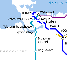
Map of Metro Vancouver rail transit network by: Matthew Buchanan
Transit modes (summary)
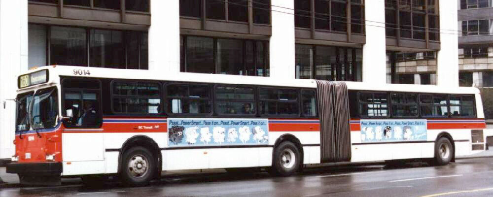
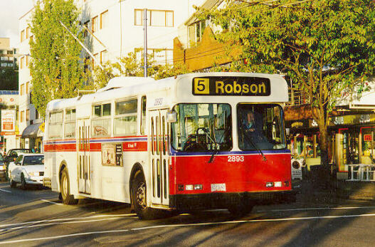
Diesel bus
Most bus service in the region is provided by Coast Mountain Bus Company, a subsidiary of TransLink. The only major exception is in West Vancouver where West Vancouver Municipal Transit has operated continuously since 1912.
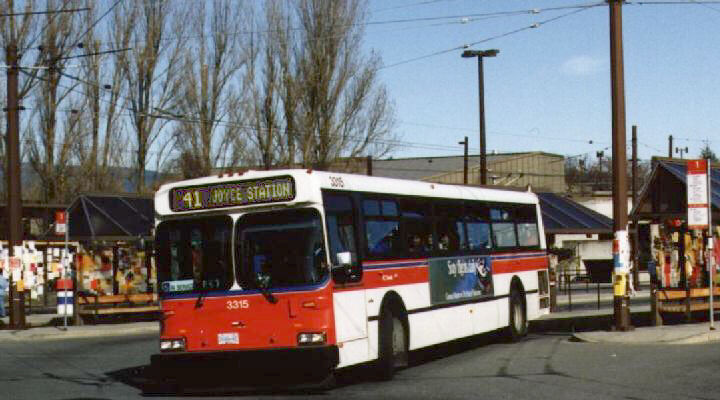
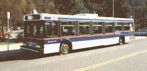
Photos: Ian Fisher (left,centre), Dennis Hui(right)
|
360 |
diesel high floor (40 feet long, GM, MCI, Flyer, New Flyer, Orion) |
| 5 | diesel high floor (35 feet long, GM) |
|
339 |
diesel low floor (40 feet long, all New Flyer D40LF) |
|
50 |
compressed natural gas (40 feet long, New Flyer C40 (25 buses), and C40LF (25 buses) (all in storage) |
|
7 |
articulated diesel high floor (60 feet long, New Flyer D60) |
| 100 | articulated diesel low floor (60 feet long, New Flyer D60LF) |
| 7 | Van conversions (Community Shuttles) |
|
30 |
West Vancouver “Blue Buses” (9 40′ Orion I, 18 New Flyer D40LF and 3 GMC T6H 5308N in reserve) |
(The fleet information above is correct for Spring 2003, except for West Vancouver which is from 1998). For a detailed roster of all TransLink and BC Transit fleets, see the unofficial BC Transit roster page.)
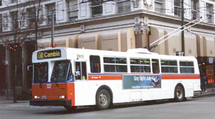
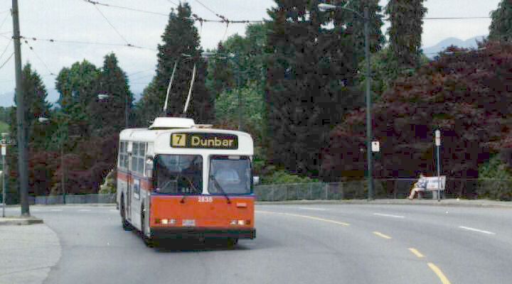
Electric trolley bus
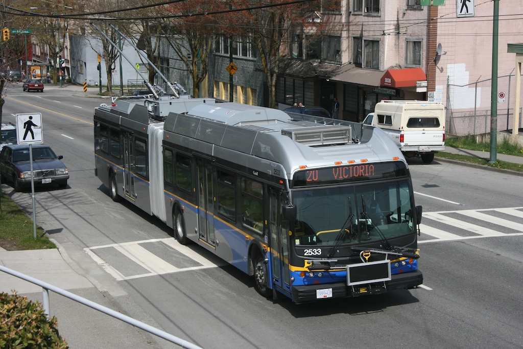

- Articulated Trolleys –
- Standard Trolleys
- Now retired – 244 Flyer E901/E902, built 1982-3 (10 buses were permanently parked for spare parts in May 2002, reducing the active fleet size to 234.)
- Trolley bus network map includes 306 km of overhead wire.
- See the Electric Trolleybus page.
- The Transit Museum Society (TRAMS) maintains and operates a small fleet of historic transit vehicles on behalf of TransLink/Coast Mountain Bus Company. The fleet includes two Brill trolleybuses which operate fan trips in the summer months. See the TRAMS site for more information and images.
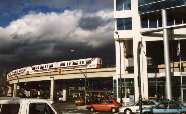
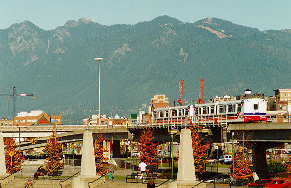
Automated light rail metro (“SkyTrain”)


- Mark I trains – 150 12 metre (40-foot) cars, semi-permanently coupled in pairs
- Mark II trains – 60 33 metre two-car trainset arrived in 2002, 48 more arriving 2009 and 2010
- The SkyTrain routes are 68.7 km long. (Expo, Millennium, and Canada Lines)
- Currently the longest automated rapid transit line in the world
- The first section opened for revenue service on 3 Jan 1986.
- Subsequent extensions opened in 1989, 1990, 1994, 2002, and 2006
- The Canada Line opened in 2009 but uses a different train technology than the Expo and Millennium Lines
- Canada line cars – 40 cars operated as 20 two-car trains
Ferry (“SeaBus”)
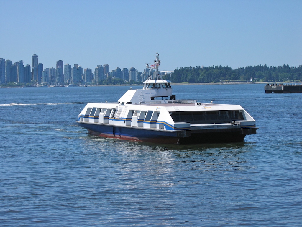
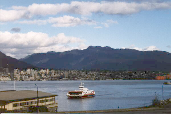
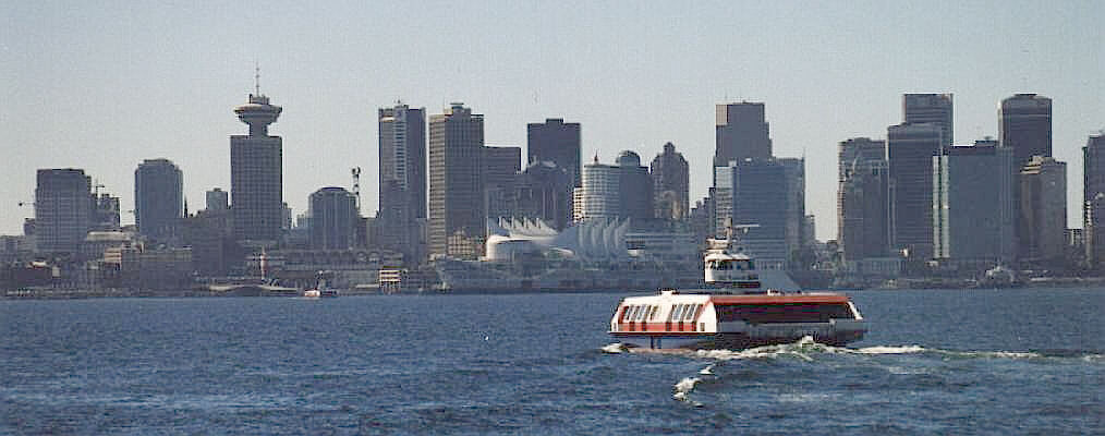
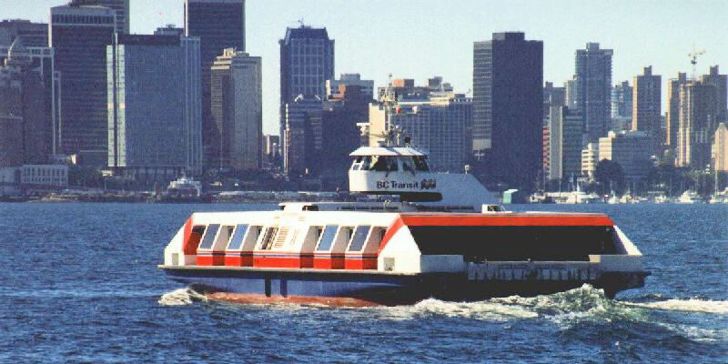
- 2 double ended catamarans seating 400, built 1977 (Burrard Beaver and Burrard Otter)
- SeaBus travels between downtown Vancouver (Waterfront Station)and North Vancouver (Lonsdale Quay).
- More facts about SeaBus.
- A new SeaBus begins service in 2010
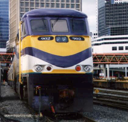
Commuter rail (“West Coast Express”)
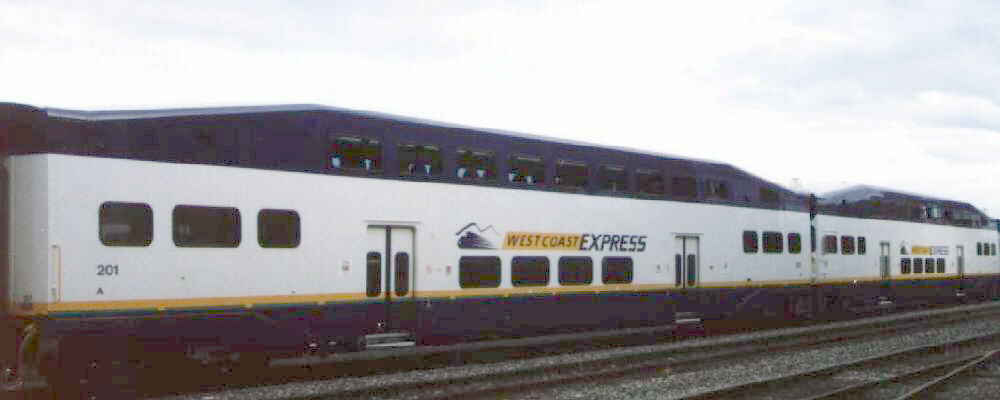
- 37 Bombardier bi-level coaches, built 1995-96
- 5 GM F59PHI diesel locomotives, built 1995
- West Coast Express travels a distance of 65 km between Vancouver and Mission.
Getting around by…
Bus
The hundreds digit of the route number indicates the region the bus operates in, as follows:
0 City of Vancouver
1 Burnaby, New Westminster, Coquitlam, Port Coquitlam, and Port Moody (municipalities to the east of Vancouver)
2 North Vancouver and West Vancouver (“the North Shore”) (municipalities to the north of Vancouver – across Burrard Inlet)
3 Surrey and White Rock (municipalities more than 30 km south-east of Vancouver)
4 Richmond (city to the south of Vancouver)
5 Langley and Fort Langley (south-east of Vancouver)
6 Tsawwassen (south of Vancouver, near one of the ferry ports)
7 Pitt Meadows, Maple Ridge (more than 30 km east of Vancouver)
Actually, the number indicates one region the bus operates in- many suburban routes operate as express buses to and from downtown Vancouver. Bus routes outside the city of Vancouver which do not go downtown will generally terminate at a major bus exchange (e.g. Ladner exchange in Ladner, Richmond exchange in Richmond, … you get the idea) or a SkyTrain station.
Timed transfers are possible at most of the outlying transit exchanges. Buses “pulse” every 15-60 minutes depending on time of day and exchange location. The timed transfer system in North Vancouver is particularly extensive.
Some of the east-west routes in the city of Vancouver are intuitively numbered. For example:
- 4 – runs on 4th Ave
- 9 – on Broadway (what would be 9th Ave)
- 25 – on King Edward (what would be 25th Ave)
- 33 – on 33rd Ave
- 41 – on 41st Ave
- 49 – on 49th Ave
North-south routes in the city of Vancouver generally start from a terminus on the south side of the city, go north to downtown, then go south to a different terminus on the south side of the city. Thus, for example, the #22 will say “Knight” on the destination sign as it travels north on Macdonald Street to downtown, since the bus will continue south on Knight Street after passing through downtown. #22 buses going the other direction on Macdonald will say “Macdonald”. This can be confusing.
The service frequency on many routes in the City of Vancouver itself is quite good – every 10 minutes or less during rush hour, every 15 minutes at other times. Some less travelled routes operate every 30 minutes. Most bus routes outside the city of Vancouver are less frequent, many operating only every half-hour or every hour. There are some extreme cases as well – the bus to the West Vancouver cemetery operates once a month! Don’t assume you can get there just because you see a bus stop!
Schedules for routes on major corridors are often meshed to give, for example, 7.5 minute service from two 15-minute routes.
Late night (Owl) service is provided on major routes, mostly within the City of Vancouver, every half-hour from 00h10 to 03h10with all routes serving downtown making a timed connection at these times. Timed connections are also made with the major cross-town routes.
West Vancouver “Blue Buses” (so called because they are painted blue) are operated by the municipality, not Coast Mountain Bus Company. Thus, there is a different telephone number for information on these routes. The fare structure is integrated with TransLink, however, and there is a TransLink logo on each bus.
SeaBus
The SeaBus provides a connection between downtown Vancouver(Waterfront Station) and North Vancouver (Lonsdale Quay) by crossing Burrard Inlet. The crossing takes 12 minutes (at 11.5knots, aka 13 mph or 21 km/h), which is considerably quicker than any alternatives since there are only two road bridges across Burrard Inlet, and both are a considerable distance from downtown.
Service is provided every 15 minutes during the day Mon. – Sat, and every 30 minutes at other times. (In other words, only one SeaBus operates in the evening and on Sundays.) 15-minute daytime Sunday service is provided in the summer months. First sailing is from North Vancouver at 602h (602h Sat, 802h Sun), the last is from Vancouver at 046h (2316h Sun). North Vancouver bus routes make timed connections at Lonsdale Quay with all SeaBus sailings. When the SeaBus is not operating in the late night and early morning, a replacement bus service (#242) is provided via the Lion’s Gate Bridge. More SeaBus facts
SkyTrain
The SkyTrain is an automated (driverless) light rail system, operated from a control centre in Burnaby. SkyTrain attendants patrol trains and stations and check fares. Most of the 28.8km(18 mile) guideway is elevated, thus permitting fabulous views of the city and mountains (if the weather is clear!).
The initial SkyTrain line opened in 1986 and is now called the Expo Line. It was given this name when the second SkyTrain lined called the Millennium Line opened in 2002
The suburban end of the Expo Line is at King George station in Surrey; the downtown end is at Waterfront Station. The downtown section uses what used to be a single track railway tunnel; the tunnel was renovated and enlarged to allow two tracks to be stacked. The section to Surrey crosses a 600 metre long, cable stayed bridge over the Fraser river. There are four stations downtown, and 33 stations in total. The Expo Line elevated stations are recognisable by the green “hoop trusses” which provide support for the station walls and ceilings. The newer stations in Surrey have distinctive styles, whereas the Millennium Line stations are quite unique from each other. Stations are open to the air but protected from the rain, since Vancouver does not get terribly cold but does get a fair bit of rain.
The trains normally operate at a speed of 80 km/h (50 mph) but are capable of 100 km/h (63 mph); the whole length of the line is normally travelled in 38 minutes, giving an average overall speed of 45.5 km/h (28 mph). Service frequency is once every 5 minutes or better all day, every day, with almost twice as frequent service during rush hours.
Currently four car Mark 1 trains are still being used but when the Millennium Line opened in 2002 a new longer SkyTrain car called the Mark 2 was introduced. The older cars are 40feet long and has a seating capacity of 36 and total normal capacity of 75. The newer Mark 2 cars are longer and are articulated permiting passengers to walk the full length of the longer car. The trains are pulled along the guideway by linear induction motors mounted on the underside of each car(hence the train does not rely on wheel to rail traction for acceleration – on the other hand, snow accumulation on the linear induction rail has caused problems). The trucks are steerable,and produce very little squeal when turning. (There were problems with excessive noise when the system was new (1986) but these problems have largely been resolved.) The system was developed by the Urban Transportation Development Corporation of Ontario, now owned by Bombardier. More technical information on SkyTrain.
The Canada Line, also an automated system, opened in 2009 and links downtown Vancouver to Richmond and the Vancouver International Airport
For more info on SkyTrain including a route map, travel times, access and more, see Translink’s SkyTrain Page
West Coast Express
The West Coast Express is a commuter train service operating between Vancouver and Mission, a city 65 km to the east. There are 5 trains into Vancouver in the morning, and 5 trains out of Vancouver in the evening. There are eight stations on the line.
West Coast Express has an official website. Also see Tom Box’s excellent page on the West Coast Express.
Fares
Please see the TransLink website for fare information.
Park & Ride
There are about 20 park & ride lots in the region as of 2008. Park & Ride lots are also available at all West Coast Express stations except Waterfront and Port Haney. Parking is generally free, although pay parking is in effect at Bridgeport Station, Production Station, Scott Road station and at West Coast Express stations in order to fund security patrols. The most distant gravel lot at Scott Road remains free and unpatrolled. Preferential carpool parking is available at some lots.
Bike & Ride
There are bike lockers at 25 SkyTrain stations as of 2009. There are also some lockers at major bus interchanges. Rental is $30 for 3 months, plus a refundable key deposit. For locker information and rental, call C-Media at 604-924-107.
There are also 64 lockers at West Coast Express stations, owned and managed by Imperial Parking (contact them at 331-7297 at their office in Waterfront Station). Rental is $45 for 3months, plus a $15 key deposit.
Bicycle on Vehicles policy
Bicycles are allowed on board SeaBus at any time. Bicycles are also allowed on board the West Coast Express, but a separate $1 ticket (or $15 monthly or $45 quarterly pass) must be bought in order to bring a bicycle on the train. There are two bicycle tie-downs per car, and cyclists are permitted to stand with bicycles in the vestibule of the passenger cars provided they don’t interfere with other passengers.
As of August 2005 bicycles are allowed on board buses or SkyTrain at all times except during rush hours in the peak direction. Rush hours are from 7-9am and 4-6pm. On the Canada Line, bikes are allowed at all times, but only 1 bike per car. See Translink’s site for more details.
Bicycle rack-equipped buses are now standard on all routes now. There is space for two bikes on the front of each bus.